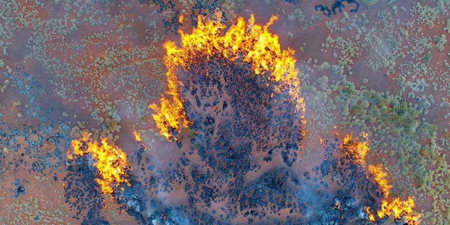
Aerial view of a prescribed burn in the Pilbara. Photo by Paul Rampant/DBCA
Much of Australia’s soil is ancient and therefore among the most nutrient poor in the world. Nutrients available for plant growth usually exist in the top ten centimetres of the soil and much of it is locked up in the biomass of the plants and animals that need it. The rate at which new nutrients are made available to the soil from decomposing bedrock is extremely slow, which means the cycling of existing nutrients is pivotal to sustaining Australian ecosystems.
Regular low to moderate intensity fire in the landscape is a primary mechanism to cycle nutrients through the soil, particularly in the drier parts of the landscape, where decomposition of biological material is usually very slow. Without fire, a great deal of available nutrients would remain locked away in forms not available for use by growing plants. The number and diversity of animals that depend on those plants would also be affected. However, very hot high intensity bushfires can cause irreversible damage to soil structure and mineral composition. These fires can sterilise the soil killing important microbes, altering the pH of the topsoil and potentially affecting plant growth and composition.
When are soils at risk?
Organic-rich soils or peatlands usually form in wet environments such as swamps, marshes and coastal wetlands. Organic rich soils are very slow to form and may take thousands of years to develop. The large amount of plant material associated within organic soils means they can become flammable when dry and highly susceptible to fire. Unlike the relatively rapid flaming combustion usually associated with bushfires in live and dead aerated vegetation, the compacted peat burns slowly by smouldering combustion. Should fire enter these ancient ecosystems, it can continue to smoulder underground for an extended period of time (i.e. weeks or months) until the soil is saturated by applied water or rain. These subsurface fires can creep along undetected for extensive distances, popping back up to the surface possibly kilometres away from the original fire location.
Care needs to be taken when suppressing fire in these environments. If these soils become exposed to the air (allowing oxygen to enter the soil) there is a risk it will trigger a reaction that may create acid sulfate soils.
Acid sulfate soils are a natural component of the landscape and may be found in a variety of waterlogged soil types. Acid sulfate soils contain chemical compounds called iron sulfides. These are harmless when buried within the soil but react when exposed to air to form sulfuric acid and potentially release dangerous amounts of iron, aluminium and heavy metals.
Acid and the heavy metals it can release from the soil may pollute waterways and groundwater, killing plants and animals, making water unsafe for human use and corroding steel and concrete structures. It is very difficult to restore soils once they become acidic. The most effective management is prevention, by avoiding the unnecessary disturbance of potential acid sulfate soils.
Works that should be undertaken with care in these areas include the creation of fire containment lines and any excavation to reach or isolate subterranean fires.
What is fire?
Fire is the visible impact of a chemical reaction called combustion. It occurs between oxygen in the air and some sort of fuel. The fuel must be heated to the ignition temperature for combustion to occur. The reaction will continue if there is enough heat, fuel, and oxygen. This is known as the fire triangle. If any of these three essential components are missing, fires cannot start or keep burning.
How do fires start?
In addition to driving fuel accumulation and fire behaviour, Western Australia’s climate systems also provide ignition sources when fuels are dry and will burn readily (e.g. summer lightning). Lightning may cause between 15-50 per cent of bushfires in WA during any given year. Human causes ignite between 40-60 per cent of bushfires every year, through accidental (e.g. fire escapes, vehicle accidents) or deliberate (arson) lighting. Weather and social factors are the main drivers that determine whether ignitions are ‘natural’ or human-induced, but it is important to realise that whatever the ignition source, fire in the landscape is inevitable.
What is fuel?
In a natural setting, fuel is comprised of live and dead vegetation that accumulates over time. Dead leaves, twigs and bark build up as they fall from trees and shrubs, but some of this material is decomposed by insects, micro flora, and fungi. Fuel can be characterised by type, size, quantity, arrangement, and moisture content.
Common types of fuels include grass, small shrubs and scrub, trees, logs, and bark.
Fuel size is classified as fine or heavy. Fine fuels, such as grasses and small twigs, are less than 6mm in diameter. Heavy fuels are greater than 6mm in diameter and include branches, logs, and stumps. Heavy fuels do not contribute to rate of spread or flame size, but add substantially to the total amount of heat released and make fire suppression more difficult.
The amount and arrangement of fuel influences fire intensity, flame length and the duration of flaming. Fuel that is tightly packed is less likely to burn and will smoulder due to lack of oxygen, whereas loosely arranged fuel will burn with more ferocity due to more oxygen. Fuel that is separated across the landscape is less likely to carry fire than fuel that is continuous. Fine, aerated fuels, such as grass, burn much faster than larger fuels such as branches and logs. More fuel means more intense fire, larger flames and longer burn time.
Fuel moisture content affects the rate at which fuels burn. The drier the fuels, the more fiercely they burn. Fuel moisture content is influenced by the humidity and temperature of the surrounding air, by solar radiation and prior rainfall. When fuel moisture is high there is less chance of a fire igniting than if the fuel moisture was low.
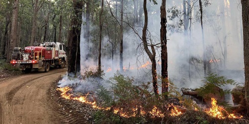
Fire requires heat, oxygen and fuel. Land managers cannot influence the heat (weather) nor can they influence the availability of oxygen. The only factor that land managers can influence is the amount of fuel. Reducing the fuel loads by prescribed burning does not prevent bushfires, but it significantly reduces their severity and damage potential.
Our department manages fuel primarily through prescribed burning. Prescribed burning is the most effective way to manage fuel loads and fuel flammability or structure. Bushfires can usually be successfully and safely controlled when they are burning into low fuel areas. Other ways to restrict the available fuel include dousing the fuel with water or fire retardants, removing the fuel on fire breaks, grazing and vegetation structure modification e.g. slashing, mulching and scrub rolling.
How do fires spread?
Fires spread in three ways: direct flame contact, radiant heat and burning embers.
1. Direct flame contact – when flames touch unburnt fuels they raise their temperature and cause them to catch fire.
2. Radiant heat – radiant heat is the heat you feel from a fire and it can cause the temperature of fuel to increase enough for it to catch fire. This can happen even before the fire reaches the fuel.
3. Burning embers – embers are burning leaves and twigs that are carried by the wind and cause small fires to start where they land. If the small fire is not put out it can smoulder, grow and spread.
Types of fire
Ground fires are sub-surface fires that burn organic material in or under the soil layer (such as peat, coal, old windrows etc).
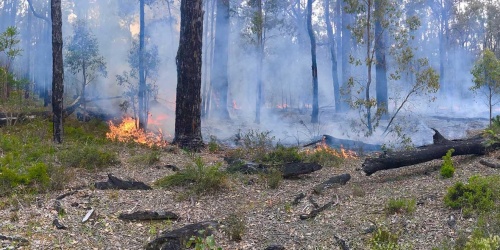
Surface fires burn in the layer of fallen leaves or needles (eg pine or sheoak) on the ground and in grasses and shrubs above fallen leaves. The layer of fallen leaves is referred to as “leaf litter” in fire terms.
Crown fires burn in the tops (or crowns) of trees above and ahead of an intense surface fire. Crown fires are caused by the flames igniting the crowns. They generally require an intense surface fire to be present before the crown will ignite. The presence of elevated fuels, high winds, low relative humidity or an uphill run of the fire may all contribute to the development of a crown fire.
What is a fire regime?
A fire regime is the combination of:
- Interval – time between fires
- Frequency – number of fires for a given period
- Size/extent – how small or large the fire is
- Season – time of year
- Intensity/severity – how much heat is generated, degree of impact on vegetation or other biota
- Mosaic – the spatial pattern of patches with different fire histories.
They operate at different spatial scales;
- Fine-scale, at a point – fire return interval, season and intensity
- Landscape-scale, regional – fire frequency in the landscape, season, severity (intensity and size), patchiness, grain size
and across different temporal scales - several years to thousands of years.
An important point to remember is that these components are related. If one component is changed, it will likely affect one or more of the others. To manage fire appropriately, all these components need to be balanced to suit the area and its inhabitants. Different vegetation types and specific species all have a favourable or suitable fire regime. When managing fire in the landscape we determine what key plants and animals occupy an area and manage fire to suit their ecological requirements.
What is fire intensity?
Fire intensity, measured in kilowatts per metre (kW/m), is the amount of energy (heat) released from each metre of head fire edge. Fire intensity depends upon how much fuel is burnt and how fast it burns. Severe bushfires, such as the Victorian Black Saturday fires, can generate intensities in excess of 100,000 kW/m, whereas prescribed fires are usually less than 500 kW/m. Only bushfires of less than 2,000 kW/m can be safely and effectively suppressed by people and machinery working directly on the flaming edge of the fire.
It only takes between five and eight years for fuel loads in most forest types to build up to a point where fire intensity is likely to exceed 3,000kW/m under summer conditions. Creating a mosaic of fuel loads across the landscape – including low fuel areas where bushfires can be easily controlled and to minimise fire runs in high fuel areas, enables safe and effective fire suppression operations to occur in these forests.
Low intensity, mosaic or patch burning is designed to provide protection to the environment and communities and is usually conducted in spring and autumn-like conditions when weather is mild and fire behaviour is moderate and easier to manage. Science-based fire behaviour models assist fire managers to plan and implement prescribed burns.
The tools and equipment that we have available for fire management operations and suppression strategies depend on fire intensity. Once fire intensity is greater than 3,000kW/m it is unlikely to be suppressed.
How does topography influence fire?
Terrain affects the speed at which a fire can travel. For example, fire moves much faster upslope than downslope. The rule of thumb is that fires travel twice as fast for every 10 degrees of slope uphill, and proportionately slower downhill (flame heights and fire intensity also significantly increase). Fast-moving forest fires can spread at speeds of up to 10 km/h which is faster than most people can run for more than a few minutes.
Fire travels faster uphill because the flames can easily reach more unburnt fuel in front of the fire. Radiant heat preheats the fuel in front of the fire, making the fuel even more flammable.
Slope aspect affects fire behaviour through the quantity and dryness of the fuels that occur there. In Australia, northern and western aspects have less, but usually much drier, fuels than southern and eastern aspects, and may support more intense fires. Northern aspects are also more likely to be exposed to the worst fire weather (hot, dry north east, north and north westerly winds).
How does weather influence fire behaviour
The most important weather variables that influence fire behaviour are wind, atmospheric humidity and temperature. Fire can also create its own weather, including firestorms and fire whirls. These are explained in detail below.
The following Bureau of Meteorology video explains how seasonal weather patterns contribute to increased bushfire danger.
Wind
Wind is a major controlling factor that determines rate and direction of spread, and shape of fire.
Wind speed affects the rate of spread of a fire and therefore its intensity. Higher wind speeds tilt the flames forward to pre-heat the fuel ahead of the fire and push the fire along increasing the rate of spread.
Wind speed also impacts the likelihood of spotting – when flames ignite leaves, twigs and pieces of bark (embers) that the wind carries aloft into the convection column. These embers then fall to start new ‘spot fires’ beyond the perimeter of the original fire. These ‘fire brands’ can remain alight for a long period and may cause new spot fires long distances downwind of the main fire. Spotting distances up to ~30km have been recorded during extreme forest fires.
The direction the wind is travelling can impact the size of the fire front. A change in wind direction can be one of the most dangerous influences on fire behaviour.
Humidity
Relative humidity is commonly used to describe the moisture content in the air. It directly affects the moisture content of dead fine fuels, and thus how readily they burn. High temperatures and low relative humidity produce low fuel moisture contents that may result in severe fire behaviour.
Temperature
Temperature affects fire behaviour indirectly through influence on fuel moisture content and local wind formation. As air temperature increases, relative humidity decreases and fine fuel moisture content decreases. Also, the higher the temperature of the fuel the more easily it will reach ignition temperature.
Fire seasons
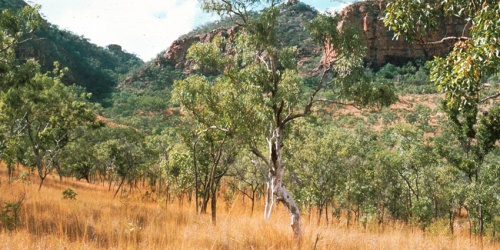
Western Australia has the longest coastline and the most extensive area of arid interior of any state in Australia and therefore experiences distinctly different climates from the north to the south.
- The north is dominated by a tropical monsoonal climate with regular wet and dry seasons each year.
- The arid interior is affected by predictable seasonal winds and extended periods of drought interrupted at irregular intervals by rainfall events such as thunderstorms and degrading tropical cyclones.
- The south has a Mediterranean type climate with dry, hot summers and wet, cool winters.
- A thin strip around the coast is affected by a maritime influence that mediates the extremes of temperature and drought.
Hot dry winds blowing from central Australia can create severe bushfire conditions. This means south western Australia is most at risk of bushfire in the dry summer months, while north western Australia is at risk during the winter months.
Parks and Wildlife Service has a close relationship with the Bureau of Meteorology, whose staff provide specialist forecasting services to the department several times a day. Accurate weather forecasts are essential for fire managers to plan the ignition and control of prescribed burns. The weather information also allows us to monitor the fire danger across the state to ensure appropriate levels of firefighting resources are pre-positioned to effectively respond to any bushfire.
Fire storms
Bushfires can produce extreme heat and a large plume of smoke and this can interact with moisture in the air as it rises to create clouds. These clouds are referred to as pyrocumulus and have a distinct crisp, white, fluffy cotton-wool-like appearance. In the right conditions, the pyrocumulus cloud can become large enough to create its own storm activity and generate lightning. A thunderstorm created by a bushfire is known as pyrocumulonimbus.
Lightning strikes from thunderstorm activity from within pyrocumulonimbus clouds can start new fires kilometres ahead of the main fire front. Spot fires can also break out as embers are swept up in the swirling winds. The strong inflow and downburst winds generated by the pyrocumulonimbus also make fires more intense and less predictable.
Pyrocumulonimbus events are unfortunately becoming more common. See the Bureau of Meteorology webpage When fires make their own weather for more information.
The pyrocumulonimbus cloud that developed during the Waroona fire in 2015 caused dangerous fireground conditions, erratic fire behaviour and numerous lightning strikes many kilometres in front of the fire.
Fire whirls
Energy created by fire can also cause spiralling columns of flame known as fire whirls. Fire whirlwinds vary in size and duration from a few metres in height and diameter that last a few seconds to massive fire tornados several hundred metres high that may last thirty minutes or longer. Fire whirls are caused by the intense local heating generated by a bushfire, producing extreme instability in the lower air above the fire itself. Most frequently, fire whirlwinds form where heavy concentrations of fuel are burning and a large amount of heat is being generated in a small area.
Large, persistent, fire whirlwinds can generate winds strong enough to lift logs, smash standing trees, and carry large amounts of soil, ash, charcoal and burning material high into the convection column. They are not fixed to their place of origin and may move across and outside the fire area. They may also move and tilt against the prevailing wind direction. Hop-overs and spot fires are often started by burning material cast outside the fireground by the whirlwind.
Fire and climate change
Climate systems affect fire behaviour and fuel accumulation. The gradual change in weather patterns due to climate change may also increase the occurrence and intensity of bushfires.
- In the south west, the climate has become warmer and drier and will likely continue to dry, with lower winter rainfall and increased average temperatures resulting in a longer ‘fire season’ and a greater proportion of the landscape that is sufficiently dry to burn.
- In parts of the interior and the tropics, it is likely that monsoonal rainfall will increase so there may be an increase in plant growth, promoting increased fuel levels.
Although hard to predict, these changes in fuel dryness and accumulation will likely influence the frequency and severity of dangerous large bushfires.
Weather is a primary consideration in all fire management operations. Adapting fire management to better understand climate change impacts, using the best available knowledge and a thorough understanding of weather conditions and patterns and their effects on fire behaviour, is fundamental to professional fire management.
How does fire affect water catchments?
Fire affects the type, structure and condition of vegetation and has a significant role to play in water productivity from catchments.
Catchments with vegetation cover that protects the soil from erosion produce clear, clean water that requires very little treatment before it gets to your tap. However, a heavy vegetation layer means much of the rainfall is intercepted and used by the vegetation. This significantly decreases the amount available as runoff into streams, rivers, dams, or infiltration into ground water aquifers.
Fire can be used to manage catchment vegetation to ensure there is enough cover to maintain water quality for environmental reasons while optimising the amount of potable water. Low intensity prescribed burns can reduce the amount of vegetation and ground cover to increase runoff without affecting water quality, whereas intense bushfires can expose the soil surface and lead to erosion. This can impact catchments by depositing silt and ash that blocks drainage channels. Bushfires can also impact water stored for human purposes, by causing turbidity, dissolving of nutrients, algal blooms, fish kills and increased water treatment costs.
How does fire affect soil?
Much of Australia’s soil is ancient and therefore among the most nutrient poor in the world. Nutrients available for plant growth usually exist in the top ten centimetres of the soil and much of it is locked up in the biomass of the plants and animals that need it. The rate at which new nutrients are made available to the soil from decomposing bedrock is extremely slow, which means the cycling of existing nutrients is pivotal to sustaining Australian ecosystems.
Regular low to moderate intensity fire in the landscape is a primary mechanism to cycle nutrients through the soil, particularly in the drier parts of the landscape, where decomposition of biological material is usually very slow. Without fire, a great deal of available nutrients would remain locked away in forms not available for use by growing plants. The number and diversity of animals that depend on those plants would also be affected. However, very hot high intensity bushfires can cause irreversible damage to soil structure and mineral composition. These fires can sterilise the soil killing important microbes, altering the pH of the topsoil and potentially affecting plant growth and composition.
When are soils at risk?
Organic-rich soils or peatlands usually form in wet environments such as swamps, marshes and coastal wetlands. Organic rich soils are very slow to form and may take thousands of years to develop. The large amount of plant material associated within organic soils means they can become flammable when dry and highly susceptible to fire. Unlike the relatively rapid flaming combustion usually associated with bushfires in live and dead aerated vegetation, the compacted peat burns slowly by smouldering combustion. Should fire enter these ancient ecosystems, it can continue to smoulder underground for an extended period of time (i.e. weeks or months) until the soil is saturated by applied water or rain. These subsurface fires can creep along undetected for extensive distances, popping back up to the surface possibly kilometres away from the original fire location.
Care needs to be taken when suppressing fire in these environments. If these soils become exposed to the air (allowing oxygen to enter the soil) there is a risk it will trigger a reaction that may create acid sulfate soils.
Acid sulfate soils are a natural component of the landscape and may be found in a variety of waterlogged soil types. Acid sulfate soils contain chemical compounds called iron sulfides. These are harmless when buried within the soil but react when exposed to air to form sulfuric acid and potentially release dangerous amounts of iron, aluminium and heavy metals.
Acid and the heavy metals it can release from the soil may pollute waterways and groundwater, killing plants and animals, making water unsafe for human use and corroding steel and concrete structures. It is very difficult to restore soils once they become acidic. The most effective management is prevention, by avoiding the unnecessary disturbance of potential acid sulfate soils.
Works that should be undertaken with care in these areas include the creation of fire containment lines and any excavation to reach or isolate subterranean fires.