Performance summary
Service 6 is responsible for developing and implementing programs for the conservation and improved management of the State’s biodiversity including animals, plants, genes and ecosystems, based on best-practice science.
Table 4: Service 6 performance summary
| 2021–2022 target | 2021–2022 actual | Variance | |
|---|---|---|---|
| Expenses by service | $65,494,000 | $63,810,000 | ($1,684,000) |
| Key efficiency indicator | |||
| Average cost per hectare of wildlife habitat | $2.03 | $2.02 | ($0.01) |
| Key effectiveness indicators | |||
| Proportion of critically endangered and endangered species and ecological communities that have a recovery plan | 72% | 74.6% | 2.6% |
| Area of land baited for introduced predators (in hectares) | 4,012,681 | 3,875,015 | (137,666) |
More information on these indicators can be found on the Disclosures and legal compliance page in the downloads section.
Performance highlights
Biodiversity conservation legislation, policy and strategic programs
- The department continued to provide advice on species, ecosystems, wetlands and risks to the conservation of threatened species and ecological communities to inform regulatory processes for key State Government initiatives and major resource developments of economic importance to Western Australia. These included bauxite mining expansion, lithium mining and processing, water for food, salt and potash, hydrogen and renewable energy, oil and gas developments, and major infrastructure including Metronet, the Morley to Ellenbrook Line, Mitchell Freeway and Tonkin Highway extensions, Bunbury Outer and Albany Ring roads, East Keralup Regional Development, the State Football Centre and Kemerton Industrial Estate.
- An additional 14 frontline approvals assessment officers and two reform officers were recruited to enable the department to meet the demand for timely assessments and approvals. This investment supports the department in the delivery of Streamline WA initiatives and ongoing approvals reform.
- The first iteration of Dandjoo, the State’s new biodiversity data sharing platform, was built ahead of its launch in the new financial year. It will deliver biodiversity data to the Commonwealth’s Biodiversity Data Repository and establish a new approach to biodiversity data management in Western Australia, making it easy for users from all sectors to share, discover, and use data.
- The department partnered with the Western Australian Museum to modernise the management of taxonomic information about Western Australian fauna, to enable a timely and automated exchange of information between the department and museum.
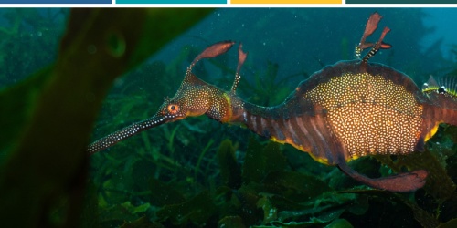
Threatened and important animals
- The numbers of threatened animals remained unchanged since the 2020–21 report, with 249 threatened animal species (57 critically endangered, 58 endangered and 134 vulnerable), 23 extinct animal species, 88 specially protected animal species (seven conservation-dependent, seven otherwise in need of special protection and 74 migratory) and 219 species on the department’s priority fauna list.
- There were 305 records of sightings, captures or evidence of threatened and priority animals added to the Threatened and Priority Fauna database.
- Following their successful translocation in 2021 to a remote location east of Albany, critically endangered western ground parrots (Pezoporus flaviventris) continued to be monitored and further translocations were undertaken in 2022.
- Monitoring of the effects of Eradicat® baiting on the specially protected red-tailed phascogale (Phascogale calura) populations continued in Tutanning Nature Reserve in the Wheatbelt using tree mounted remote cameras. Ongoing monitoring will help inform future feral cat management in phascogale habitat.
- Surveys and monitoring were undertaken for numerous threatened and priority animals, including heath mouse (Pseudomys shortridgei), chuditch (Dasyurus geoffroii), western ringtail possum (Pseudocheirus occidentalis), snubfin dolphin (Orcaella heinsohni), purple-crowned fairy-wren (Malurus coronatus), northern quoll (Dasyurus hallucatus), golden bandicoot (Isoodon auratus), golden-backed tree-rat (Mesembriomys macrurus), brush-tailed rabbit-rat (Conilurus penicillatus) and greater bilby (Macrotis lagotis).
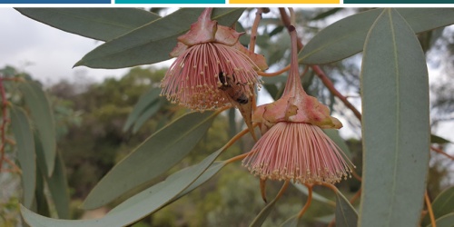
Threatened and important plants
- At 30 June 2022, there were 429 extant threatened plant species (160 critically endangered, 140 endangered and 129 vulnerable), 15 listed as extinct and 3411 taxa on priority flora list.
- A total of 858 populations, comprising 388 species of threatened and priority plants, were surveyed or monitored, and 71 new populations of threatened plants and 197 new populations of priority plants were located. Of the 2287 records added to the Threatened and Priority Flora database, 458 were for new populations.
- The WA Herbarium collection increased by 11,317 specimens, bringing the total number of specimens held to 833,034. A total of 625 names were added to the WA Plant Census.
- Names for 46 taxa were published in the WA Herbarium journal Nuytsia.
- The WA Herbarium is migrating to a new collections management system and 86,086 specimen records were edited as part of preparatory names curation and data cleaning.
- A total of 130 seed collections of conservation significant species were banked at the WA Seed Centre, which now holds seed collections of 386 threatened plant and 890 priority plant species. The department continued to provide technical advice and assistance for projects involving seed collection and use. Collections of nine critically endangered, three endangered, and one priority species were withdrawn from the seed bank and germinated for use in department translocation projects.
- Spatially explicit analysis of patterns of occurrence of threatened and data deficient flora across the Southwest Australian Floristic Region was undertaken, allowing for identification of flora conservation hotspots to support conservation planning.
- The latest iteration of the WA Herbarium’s web application Florabase was launched, providing new features, including greater access to specimen data, improved mapping, and an enhanced search capacity.
- The department contributed to the new edition of the Australian Soil and Land Survey field handbook by providing definitions of vegetation attributes consistent with remote sensing approaches.
- A seven-year investigation of temporal changes in critically endangered Ptilotus densities and the impacts of weed control on Ptilotus at Greater Brixton Street Wetlands provided information to guide management actions of this species.
Threatened ecological communities
- At 30 June 2022 there were 65 extant ecological communities listed as threatened through a non-statutory process (20 critically endangered, 17 endangered and 28 vulnerable), and four listed as collapsed. Another 390 ecological communities were on the priority list.
- Two meetings of the Threatened Ecological Community Scientific Committee were held and final comments were provided regarding assessing the threat rank for 65 extant and three collapsed ecological communities. International Union for Conservation of Nature listing criteria was used in preparation for consideration for listing under the Biodiversity Conservation Act 2016 (BC Act).
- New information was added to the Threatened and Priority Ecological Communities database for 548 occurrences of Threatened Ecological Communities (TECs) and Priority Ecological Communities (PECs) distributed across the State. Surveys were completed in 61 occurrences of TECs and PECs throughout the State.
- To help combat Phytophthora dieback, aerial spraying with phosphite was completed for two TECs and two PECs in the South Coast Region.
- Draft survey and identification methods were compiled for 65 TECs and released for public comment for three months on the department’s website.
- Surveys and reports were completed for 650 hectares of vegetation on private land for consideration for inclusion in the reserve system, dependent on conservation values and the presence of TECs.
- Department monitoring data and other information on 12 Western Australian TECs and three PECs featured in the Global Ecology and Biogeography publication about fire-related threats to ecosystems.
- Camera hydrological monitoring and geochemical data for the Mandora mound springs TEC helped identify groundwater sources sustaining the springs and assess their resilience to climatic changes and water availability.
Managing threats
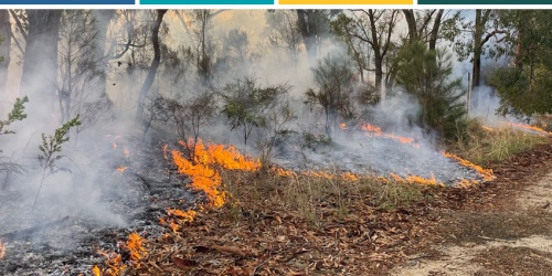
- The department reviewed the Cane Toad Strategy for Western Australia 2014–19 and prepared the Cane Toad Strategy for Western Australia 2021–26. It will continue to focus on mitigating the impact of cane toads (Rhinella marina) on native wildlife, while continuing community engagement and quarantine strategies. Research continued into taste aversion therapy of northern quolls, goannas (Varanus species), freshwater crocodiles (Crocodyllus johnstoni) and other threatened and specially protected taxa.
- Phosphite was applied to 141 hectares of Montane Heath and Thicket TEC, Montane Mallee Thicket PEC, Kwongkan TEC, Banksia coccinea shrubland, Melaleuca striata and Leucopogon flavescens Heath PEC and occurrences of 15 threatened flora (including 11 critically endangered) species. Backpack application of phosphite for dieback control was undertaken on highly susceptible species such as Lambertia echinata subsp. occidentalis and Banksia nivea subsp. uliginosa within the critically endangered Shrublands on Southern Swan Coastal Plain Ironstones (Busselton area) TEC.
- The department continued to administer the system for registering dieback interpreters and monitoring standards of interpretation. In 2021–22 there were 24 registered interpreters (17 employed by the department and seven in the private sector).
- Desktop checks of 258 activities and nine field checks were undertaken to monitor dieback management of disturbance activities.
- An online version of the Green Card course in dieback and plant biosecurity awareness and basic management was completed by 522 students, with a further 22 students completing the face-to-face version of the course. The Dieback Management Planning course was delivered to 22 students in Walpole and Bunbury.
- Surveillance was undertaken for myrtle rust in the East Kimberley in collaboration with the Queensland Department of Agriculture and Fisheries. Germplasm for species considered to be susceptible to myrtle rust was also collected.
- The department expanded investigations of tolerable fire intervals in sensitive plant species, finding that the juvenile period correlates with environmental productivity and that predicted climatic changes are likely to lead to longer juvenile periods. The models developed predict how minimum tolerable fire intervals may change across space and time.
- Research was conducted to develop and refine on-ground and remote sensing approaches to survey and mapping of fine-scale variation in fire severity. This improves reporting of fire impacts and prescribed burning outcomes.
- Operations to prioritise, review and manage priority environmental weeds continued throughout the State, including through collaborative efforts with traditional owner and community groups.
- The Mimosa pigra eradication program on the eastern shores of Lake Argyle continued, managed by the department’s Aboriginal Rangers for Reserve 31165 project.
- Wild dog management continues in collaboration with recognised biosecurity groups to ensure a coordinated landscape-wide approach to minimising the impact of wild dogs on agricultural and pastoral production.
- Trials of the Felixer grooming traps for controlling feral cats continued.
- Field trials were completed to assess the effectiveness of a grass-selective herbicide, fluproponate, to control African lovegrass (Eragrostis curvula) and assess any off-target native vegetation impacts.
- In cooperation with landholders, installation of strategic fencing, mustering and aerial culls of cattle, donkeys, camels, horses and pigs were undertaken to maintain and protect the cultural and natural values of parks and reserves throughout the Kimberley Region.
- The department improved its fire history knowledge in the Great Western Woodlands to inform fire management of long unburnt woodland environments with high biodiversity values.
- Ongoing management actions were undertaken including fencing, signage, feral and pest animal control, weed mapping and control, hydrological investigations, monitoring, revegetation, dieback control, rubbish removal and fire management to protect threatened and priority animal and plant populations and ecological communities across the State.
Western Shield
- The Western Shield wildlife recovery program continued to implement broadscale fox and feral cat control for native animal conservation across a network of sites. Approximately 3.75 million hectares of department-managed and adjoining lands across Western Australia were baited as part of the core program involving the use of approximately 592,000 fox baits and 656,000 Eradicat® feral cat baits. Regular monitoring of baited areas continued to track the recovery of native species.
- The number of volunteers who have used the Western Shield Camera Watch web page to help classify a significant number of remote camera images is now at over 10,000.
- A total of 24 sites were monitored for native fauna using Western Shield methods. In addition, Western Shield and associated programs monitored 22 sites for predators.
Wildlife sanctuaries and translocations
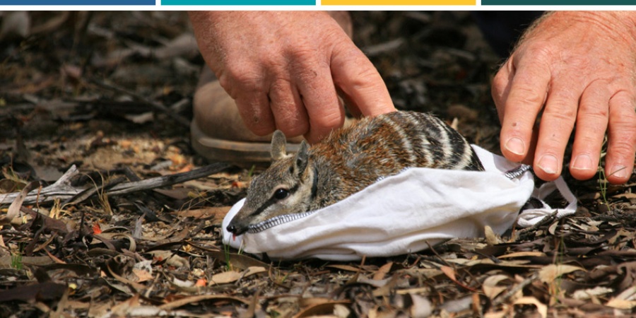
- Genomic analyses on wild and translocated populations of threatened and specially protected species, including boodie (Bettongia lesueur), rufous hare-wallaby (Lagorchestes hirsutus), golden bandicoot, black-flanked rock wallaby (Petrogale lateralis lateralis), Gilbert’s potoroo (Potorous gilbertii), woylie (Bettongia penicillate ogilbyi), Shark Bay mouse (Pseudomys fieldi) and chuditch informed translocation planning and metapopulation management.
- The department worked with Perth Zoo on the wild release of five endangered numbats, 36 endangered dibblers (Parantechinus apicalis) and 73 critically endangered western swamp tortoises (Pseudemydura umbrina).
- A program to rear vulnerable orange-bellied frogs (Geocrinia vitellina) and critically endangered white-bellied frogs (Geocrinia alba) led to the release of 107 white-bellied and 40 orange-bellied frogs to supplement wild populations near Margaret River. Additionally, 68 populations and sub-populations of frogs were monitored and UWA utilised this dataset to define the species’ habitat requirements and model abundance to assist with the selection of future translocation sites. One new white-bellied frog translocation site was established and six new sub-populations discovered on a newly acquired property near Karridale.
- Trial translocations of western swamp tortoise to two locations near East Augusta were undertaken in anticipation that climate change will improve habitat to the south and cause existing northern sites to become drier and less suitable.
- Monitoring of critically endangered woylies and endangered numbats at Dryandra Woodland National Park continued to show positive trends in recovery following integrated fox and feral cat control.
- Perup Sanctuary continued to support robust populations of woylies and critically endangered western ringtail possums and show signs of breeding.
- Control of foxes and relocations of quenda (Isoodon fusciventer), both predators of western swamp tortoise, to urban and peri-urban sites continued in collaboration with local governments and Friends groups at Ellenbrook and Twin Swamps nature reserves.
Marine Science
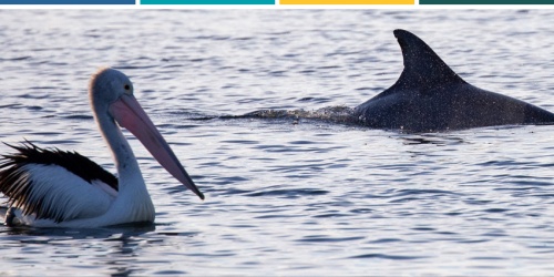
- The department’s marine monitoring program collected data and reported on the condition of, and pressures on, key ecological values in Western Australia’s marine reserves. Surveys were conducted at Walpole and Nornalup Inlets, Ngari Capes, metropolitan Perth, Jurien Bay, Shark Bay, Ningaloo, Montebello and Barrow Islands, Eighty Mile Beach and the inshore Kimberley marine parks. Baited Remote Underwater Video data from the program contributed to a major national collaborative study that examined marine reserve fish assemblages in relation to management zoning.
- Along with biological surveys, research continued to address key management-related knowledge gaps regarding ecological processes and key pressures in marine reserves. Key achievements included a study describing coral assemblages in temperate marine parks and an exploration of novel techniques to monitor fish assemblages at Jurien Bay Marine Park. Research also continued at Ningaloo Marine Park to investigate the influence of environmental conditions on algal diversity and abundance and to quantify the value of this habitat to fishers.
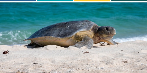
- The presence of toxins and plastics in turtles was investigated and turtle growth rates were estimated.
- Studies of the influence of heat stress induced seagrass fragmentation on fish diversity and abundance is underway at Monkey Mia in the Shark Bay Marine Park.
Rivers and Estuaries Science
- The Swan Canning Estuarine Response Model was updated and used to support water quality improvement planning. The model was coupled to a catchment model to simulate water and nutrient generation in the Swan Canning estuary and to understand estuarine response to flows and nutrients. It was also used to compare historic data on prawns, dolphins, fish communities and the movement of acoustically tagged fish. This will assist in determining the drivers in the patterns observed in the biological datasets.
- The department continued to deliver weekly water quality monitoring at 41 sites throughout the estuary and fortnightly monitoring at 33 sites within the catchment.
- The annual monitoring of seagrass and fish communities was completed and the 2019–20 estuarine and 2019 catchment data reports were made available on the department’s website. Interactive online reporting is being developed to improve data analysis and reporting.
- River incident responses involved investigations of flooding and fish kills and weekly updates were provided to key stakeholders on the levels of the harmful algae Alexandrium between spring and autumn.
- Progress was made towards developing a locally relevant environmental DNA reference library of freshwater fish and crayfish species, and in partnership with UWA, a pilot project is being undertaken to develop DNA monitoring of the Canning River to detect the movement of both native and feral fish.
- Key Performance Indicators were determined for water quality, seagrass, fish communities and oxygenation over a five-year period in the Swan Canning River Protection Strategy.
- Juvenile bull sharks (Carcharhinus leucas) were tagged and acoustically tracked within the Swan Canning Riverpark. This will improve understanding of the residency time and movement of juvenile sharks, the habitats used within the estuary and responses to changes in environmental conditions.
- As part of the State Government’s 2021 election commitment of $2 million over four years, the department established the Swan Canning Riverpark Habitat Creation Project. This allows for new research and the construction of in-water artificial habitat, with the aim of enhancing biodiversity, attracting fish and improving water quality. It includes a funding commitment that is intended to support expansion of The Nature Conservancy (TNC) Mussel Reef Restoration Project, to which the department provides specialist advice through a Technical Advisory Group.
Wetlands
- Toolibin Lake experienced a winter fill event for the first time in nearly 40 years. High resolution topographic data was acquired and a hydrological monitoring program was developed in collaboration with the Australian Nuclear Science and Technology Organisation, to assist in refining management triggers and actions. Responses of wetland fauna to the filling event were monitored and the department continued delivery of the Toolibin Lake Catchment Recovery Plan, including the planting of 39,000 seedlings around the catchment.
- Research to understand how groundwater supports mound springs at Walyarta (Eighty Mile Beach Ramsar site) continued through the monitoring of surface water hydrology around selected springs. This will help to identify different spring sites and understand the longevity of spring flow. The approach is transferable to other springs and will help assess their resilience to changes in climate.
- Work continued with the CSIRO in trialling different geophysical methods to map and assess sediment and groundwater salinity in the Greater Brixton Street Wetlands. The results provide information on the geochemical condition of root-zone sediments that support rare flora and fauna and will help inform their management.
- The department continued to operate the diversion weir at Lake Mealup that is part of the Ramsar-listed Peel-Yalgorup wetlands, to manage water levels for important waterbird habitat and reduce acidification of the lake bed.
- Research to understand the factors associated with the climate change driven acidification of peat wetlands in the Muir-Byenup System Ramsar site was completed. This was achieved with support from the National Landcare Program Phase Two via South West Catchments Council and investigated how changes in climate altered the geochemistry and water holding capacity of the peat within four wetlands. Results will be important for fire management around peat wetlands.
Forest science
- Analyses of the second round of sampling from FORESTCHECK sites were completed and proposed for publication. Trials of the benefit of environmental DNA and metabarcoding for monitoring fauna and soil biota in the jarrah forest continued.
- Examination of the vulnerability of forest ecosystems to climate change in terms of structure, composition regeneration and functioning continued using drought-affected and bushfire-affected forest study sites in the Yarloop fire scar.
- Monitoring and investigations into areas of forest vegetation density decline, using remote sensing trend maps and on-ground validation examining forest health, site and stand associations and climatic influences, continued in the north and east of the northern jarrah forest and extended to the Collie region.
- The department continued long-term monitoring of the western ringtail possum and other native species in the Greater Kingston area in the Upper Warren region, which supports the largest remaining inland population of the western ringtail possum.
Off-reserve conservation
- The department’s Land for Wildlife program, in partnership with NRM WA, registered 33 new properties, bringing the total area of registered sites managed privately for conservation to 1,048,742 hectares over 2002 properties.
- The Nature Conservation Covenant Program registered 16 new covenants (15 conditional and one voluntary) and is currently negotiating six voluntary and eight conditional covenants. Covenants have been established on 396 titles covering 30,457 hectares, including habitat for threatened species and ecological communities, a Ramsar-listed wetland and registered Aboriginal heritage sites.
- The Urban Nature program collaborated with regional Landcare groups, community groups, local governments and State Government agencies to facilitate best-practice management of urban bushland. This included field days, workshops, restoration trials, the publication of Bushland News to encourage community involvement in bushland conservation and maintenance of the ‘Find a conservation group’ app to assist people to volunteer.
- Support was provided to Karajarri Rangers to carry out camera surveys of rocky outcrops for black-flanked rock-wallaby and northern quoll within Walyarta Conservation Park and the adjoining Karajarri Indigenous Protected Area.
- The department and Nyangumarta Rangers completed a survey for black-flanked rock-wallabies in a population within the Nyangumarta Indigenous Protected Area that was first recorded in 2018. Genetic material was taken to assist with clarifying taxonomy for this population.
Sustainable use of natural resources
- The Management Plan for the Commercial Harvest of Kangaroos in Western Australia 2019–23 continued to be applied to ensure the sustainable commercial harvest of western grey and red kangaroos (Macropus fuliginosus and Macropus rufus) in Western Australia. Quotas will continue to be set for each management region.
- The management of commercial flora harvesting continued to be regulated under the Management of Commercial Harvesting of Protected Flora in Western Australia 2018–23, which was also approved by the Australian Government.
- Improved management protocols are being developed for the ecologically sustainable use of wild growing sandalwood (Santalum spicatum).
Licensing and Ministerial authorisation
- Under the BC Act, the department issued 5893 licences to take, collect, keep and breed, deal in, trap, import or export native animals, and 775 licences to collect, supply, deal and process native plants, including sandalwood. A further 183 licences were issued to either scare, destroy, trap or relocate nuisance wildlife or dangerous wildlife and wildlife causing damage.
- Also under the BC Act, Ministerial authorisation is required for the take and disturbance of threatened species (plants and animals) and the modification of TECs. There were 176 (including seven amendments) fauna authorisations and 179 (including 22 amendments) flora authorisations granted.