Mountain Country, located in the Great Southern region of Western Australia, features two remarkable ancient mountain range national parks – Porongurup and Stirling Range (Koi Kyeunu-ruff). This area also includes the surrounding towns and villages. Spanning from Gnowangerup, west to Cranbrook, south to Mount Barker and east to Porongurup, this scenic region is easily accessible from the city precinct of Albany and only four hours south of Perth.
Home to the Mineng, Goreng and Kaneang Noongar peoples, these two unique and contrasting mountain ranges are within close proximity—an unusual phenomenon in geology. They reside in a very old continent, rich in spiritual and ecological significance.

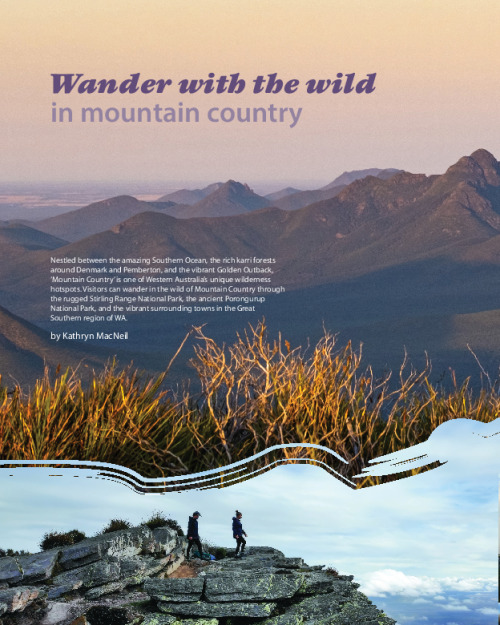
Stirling Range is known as Koi Kyeunu-ruff by the local Mineng and Goreng Noongar peoples. Photo – Lex Porebski
PWAKKENBAK
Pwakkenbak, or Mount Barker Hill, was once a lookout for the Menang people —a place to locate family, to observe the land and to hunt. It is one of the most spectacular outlooks in the south-west of Western Australia, with views across the Stirling Range (Koi Kyeunu-ruff), Porongurup and as far south as Albany (Kinjarling).
Only a short drive from the vibrant town of Mount Barker, Pwakkenbak is the perfect starting point for all Mountain Country adventures.
Atop the hill is a short, accessible nature walk and boardwalk, as well as fantastic interpretive signage telling the stories of the region. Apart from the stunning daytime views, the hilltop is also a mecca for dark sky astronomy. Moonrises and sunrises, as well as star gazing, and planet gazing are ‘must do’s’ when in the region on a clear night. Some visitors are even fortunate to witness the Southern Lights, Aurora Australis, from the lookout.
Pwakkenbak is also the site of a state of-the-art mountain bike trail network. Along with a thrilling new adventure playground and pump track in the nearby Wilson Park, the Pwakkenbak mountain bike trails are due to be opened in 2025.
The town of Mount Barker is home to a burgeoning art scene, with a collection of historic and colourful wall murals, community and commercial art galleries and public art works. The town can be easily explored on foot with self-guided and bookable tours available from the local visitor centre.
The town is also the centre point for the internationally recognised Mount Barker wine region, known particularly for its riesling and shiraz production, but also boasting several unique family-owned and operated vineyards and wineries.
On the outskirts of the town, a little known 500-hectare Class A Bush Reserve is home to one of the richest collections of native orchids in Western Australia. With 41 species of native orchids identified, the bushland is an enthralling natural environment to discover.

Porongurup Range. Photo – Marie Lochman
ANCIENT SACRED PORONGURUP
Porongurup originates from the Noongar words ‘Borungur’ and ‘up’ meaning ‘place of totem spirits’ and is viewed by many as one of the most sacred places in the south-west. It is revered as the spiritual home of Noongar ancestors and represents a connection with nature and Country, which is central to their beliefs. Hunting is forbidden and many local Noongar people still avoid the mountain peaks, out of respect to the home of wagyl, the snake spirit. Mummari, elusive and mischievous spirits, also roam the mountains after dark, warding off nocturnal activities.
Porongurup is a small, yet ancient range spanning 12 kilometres in length and running from east to west, with its highest peak, Devil’s Slide, reaching 670 metres above sea level.
The lush Porongurup Range National Park features a wonderful array of hiking trails and nature experiences—tall karri forest, dense understory, towering granite peaks with masses of lichen, moss and fungi, tiny insects observing the world and an array of birds, singing their native songs.
There are six classified trails in the national park, including the Class 2 Bolganup Trail, suitable for all levels of hiking experience, and the very popular Class 5 Granite Skywalk Trail—a trail not for the faint-hearted! All trails in the range offer a combination of open spaces and woodland areas, and hikers can enjoy the comforts of the peaceful picnic areas, public toilets and shared barbeques at the two main carparks—Castle Rock and Karri Boya-k (Tree in the Rock).
. Photo – Ann Storrie")
Queen of Sheba (Thelymitra speciosa). Photo – Ann Storrie - Photo Ann Storrie
RUGGED WILDERNESS OF KOI KYEUNU-RUFF
The Noongar name for the Stirling Range, Koi Kyeunu-ruff, which means ‘a place of ever-moving mist’ is also steeped in significance to Noongar people. A place of powerful natural forces, it is held in awe and respected to the present day. The malevolent spirit, Noatch, is believed to be the visible form of the mist which moves through the mountains and gullies.
Koi Kyeunu-ruff (Stirling Range) spans 65 kilometres from east to west and is only 40 kilometres north of the Porongurup. The range rises 1095 metres above sea level at its highest peak, Bular Mial (Bluff Knoll), which receives over 100,000 visitors each year. The mountain range is popular with avid hikers and explorers, seeking that coveted prize of a selfie atop the mountain at sunrise. But this adventure hotspot is not for the fainthearted.
More than a billion years ago, the area was covered by a shallow sea, with minerals, dead plants and sea animals forming a layer of sediment. As the Australian continent grinded and shifted against the Antarctic continent, the tectonic plate shifted, forming the mountain range we see today.
There are six classified trails in the Stirling Range National Park, ranging from the Class 4 trails at Bluff Knoll, Mount Trio and Mount Hassell, to Class 5 at Toolbrunup Peak, Mount Magog and Talyuberlup. Hikers are recommended to carefully prepare for hikes in these mountains—all walks are steep and have uneven surfaces, and the weather can change very quickly.
Koi Kyeunu-Ruff is also recognised as one of the floristically richest areas in one of the world’s top 35 hotspots for biodiversity and is now on the Australian National Heritage List. The park is particularly rich in banksias, eucalypts, orchids and verticordia (feather flowers). 1500 different flowering species can be found in the park, with more than 87 species endemic to the area. Find these treasures on foot or on a guided tour offered by one of the Stirling Range tourism businesses.
To the east of the range, is the agricultural town of Cranbrook, which is also home to a spectacular lookout, Binjellup (Sukey Hill, named after William Sukey, a local grazier), with views to the western end of the Stirling Range. It was predicted in the 1990s that much of the land to the north of Binjellup, and even around the town of Cranbrook, would turn salty because of farming practices that cleared native vegetation, leading to a rising water table. Local Landcare groups have championed the restoration of many properties. However, the vibrant Pink Lake, northeast of Cranbrook is a popular photo stop for visitors.
To the east of the range is the friendly town of Gnowangerup, named after a local bird, the ‘gnow’ meaning malleefowl. The town is also part of the entertaining Horsepower Highway—a trail of vintage and quirky tractors leading to the Stirling Range National Park. The length of the trail is 75 kilometres but offers beautiful country scenery as well as some great photo opportunities along the way.

Horsepower Highway is a trail of vintage tractors leading to Stirling Range National Park. Photo – Mountain Country Tourism
TWIN CREEKS CONSERVATION RESERVE
Nestled between the two Mountain Country ranges is Twin Creeks Conservation Reserve, operated by a local conservation group with the purpose of showcasing and protecting local flora and fauna. The reserve offers an extensive range of trails throughout, but the green trail is most accessible and popular with visitors.
Alongside the reserve is a captivating Aboriginal sculpture, Genestreams, which makes visible the shared ancestry of local species and culture. The 3.5-metrehigh evolutionary tree is a collaboration between Indigenous and non-Indigenous artists and conservation groups.
PAVING THE PATH FORWARD
Mountain Country Tourism, an association of businesses in Plantagenet, Cranbrook and Gnowangerup, and operators of the Mount Barker Visitor Centre, is forging a path forward to recognise and celebrate this significant part of the Australia’s south-west.
Collaborating with local leaders, tourism visionaries and funding partners, the association is not only promoting Mountain Country as a must-see destination but is also working with stakeholders to build the capacity of the tourism industry and facilitate greater visitor numbers to the region. A brand-new Mountain Country Visitor Guide has been released, showcasing the places to visit, where to stay and eat, and the memorable events that are held each year in the region.
As a ‘for purpose’ organisation, Mountain Country Tourism relies on the support of community and partners to ensure that this spectacular part of Australia is showcased and celebrated to the world.