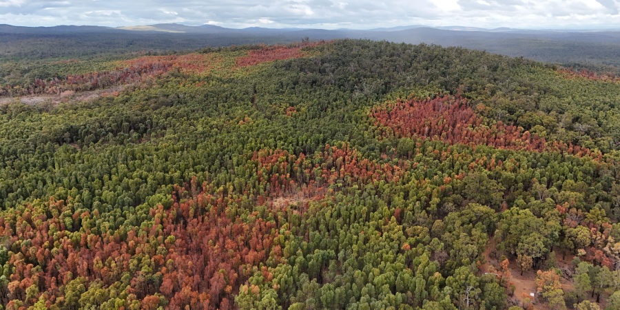
Patchy die-off of jarrah forest from the 2023-24 heatwave and drought event experience in south-west WA. Photo - Dr Joe Fontaine
What do bananas and drought-stressed forests have in common?
According to new research led by the Department of Biodiversity, Conservation and Attractions (DBCA) in collaboration with Murdoch University, both contain potassium and a tiny amount of naturally occurring radiation that can reveal important clues about the world around us.
The research, published recently in Geophysical Research Letters, demonstrates that gamma-rays can identify "hidden" subsurface factors that determine whether trees will survive or perish during record-breaking drought and heat events.
The discovery could help land managers identify the areas most vulnerable to future forest die-off, providing a new tool to build resilience in a changing climate.
The study follows the widespread but uneven forest die-off seen across south-west Western Australia during the record-breaking 2023–24 drought and heatwave. While forests across the region experienced the same extreme conditions, some areas were far more severely affected than others.
Researchers found the answer lies beneath the surface.
Trees growing in deep soils have access to larger stores of water that help them survive prolonged dry periods. In contrast, trees growing on shallow soils above bedrock have much less water available and are more vulnerable when drought and heat strike.
Using airborne sensors, the research team measured gamma rays produced by the natural decay of potassium-40, a naturally occurring radioactive isotope found in rocks and soils. In the highly weathered landscapes of south-west Western Australia, potassium has largely been leached from the soil over millions of years, meaning stronger potassium signals often indicate that bedrock is closer to the surface.
Lead author Dr Gavan McGrath from DBCA said the technique allows scientists to uncover landscape features that are otherwise difficult to detect across large areas.
"The forests don't all experience drought in the same way. What happens beneath the ground can be just as important as what happens above it," Dr McGrath said.
"Using airborne gamma-ray data allows us to map hidden features of the landscape over very large areas and identify forests that may be more vulnerable to future drought and heatwave events."
By comparing gamma-ray signals with satellite observations and on-ground surveys, the researchers were able to accurately identify areas with shallow soils and limited water storage capacity — the same areas that experienced the greatest levels of tree death during the 2023–24 drought.
Dr Joe Fontaine, lecturer and researcher in fire ecology at Murdoch University said the findings could help land managers better prepare for future climate extremes.
"This technology gives us a practical way to identify high-risk areas before major die-off occurs, allowing management efforts to be targeted where they can have the greatest impact.
"As droughts and heatwaves become more frequent and severe, understanding where forests are most vulnerable will be critical to protecting biodiversity and maintaining healthy ecosystems."
The study also found that airborne measurements can reveal the influence of bedrock depth many metres below the surface, providing insight into subsurface conditions that are typically difficult and expensive to map.
The approach has potential applications well beyond Western Australia. Similar highly weathered, nutrient-poor soils occur across approximately one-third of the Earth's ice-free land surface, including parts of the Amazon Basin, sub-Saharan Africa and Southeast Asia.
ENDS
Media contact
DBCA Media: 9219 9999 or media@dbca.wa.gov.au.
(for interviews with Dr Gavan McGrath)
Murdoch University: 0407 804 792 or news@murdoch.edu.au.
(for interviews with Dr Joe Fontaine)