Walpole Nornalup National Park. Photo by Fiona Felton/DBCA
The Department of Biodiversity Conservation and Attractions (DBCA) coordinates mapping of wetlands in Western Australia. Mapping the extent of wetlands and their values improves our ability to make informed decisions about the management, protection and conservation of wetlands. As a minimum, mapping identifies the presence of wetlands but can also identify the wetlands boundary (extent), type (classification), and assigned wetland management category (evaluation).
Wetland mapping at an appropriate scale and level of detail is necessary for wetland management and decision making. Many different styles of wetland maps exist which have been developed at different scales, using different techniques and for different purposes. Some areas of the state have been mapped at a fine scale, while comprehensive wetland mapping has not been conducted in other areas.
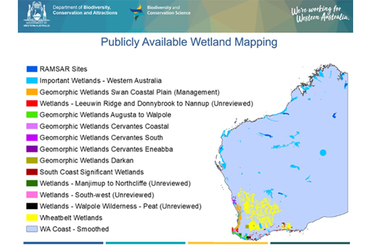
The department maintains, and is the custodian of, several wetland datasets (see map below). As described under the headings below, the Ramsar and the Directory of Important Wetland datasets provide site boundaries for important wetland areas across Western Australia whereas our other dataset map wetlands within a discrete portion of the State.
Ramsar – internationally important wetlands
The Ramsar Sites dataset displays the official boundaries of current and proposed Western Australian wetlands listed as Wetlands of International Importance under the Ramsar Convention.
More information regarding Ramsar sites including Ramsar information sheets are available on the Wetlands of national and international importance web page.
The Ramsar Sites dataset (DBCA-010) can be downloaded for free via Data WA or viewed via Landgate’s public map viewer, Locate.
Downloads
Directory of Important Wetlands – nationally important wetlands
The Directory of Important Wetlands dataset displays the locations and boundaries of the Directory of important wetlands sites in Western Australia.
This dataset was last updated in 2018 by DBCA based on the descriptions published in A directory of important wetlands in Australia (Environment Australia) 3rd edition, which is available from the DBCA Library. More information regarding these sites is available on Wetlands of national and international importance web page.
The Directory of Important Wetlands in Australia – Western Australia dataset (DBCA-045) can be downloaded free via Data WA or viewed via Landgate’s public map viewer Locate.
Downloads
Midwest
There are three wetland datasets for the southern portions of the Midwest, encompassing Cervantes, Jurien Bay, Greenhead, Eneabba and Cataby town sites. Some of these datasets overlap each other.
Geomorphic Wetlands Cervantes Eneabba dataset
This dataset displays the wetland boundaries (extent) and geomorphic wetland classification (type). It covers an area from Cervantes to 7km west of Badgingarra and from 8km north of Coolimba to 15kilometres east of Eneabba.
The western portion of this dataset has been mapped, at a finer scale, in the Geomorphic Wetlands Cervantes Coastal dataset.
Geomorphic Wetlands Cervantes Coastal dataset
This dataset displays detailed wetland boundaries (extent), geomorphic wetland classification (type) and wetland management categories (evaluation). It includes wetland mapping for a 17km wide coastal strip from 6km south of Cervantes to 10km north of Coolimba.
This dataset overlaps portions of the Geomorphic Wetlands Cervantes Eneabba dataset.
Geomorphic Wetlands Cervantes South dataset
This dataset displays detailed wetland boundaries (extent), and geomorphic wetland classification (type). It covers an area between Cervantes and Cataby in the Shire of Dandaragan, on the northern Swan Coastal Plain.
This dataset adjoins both of the other Midwest datasets.
These three wetland datasets:
- Geomorphic Wetlands, Cervantes Eneabba dataset (DBCA-015)
- Geomorphic Wetlands Cervantes Coastal dataset (DBCA-014)
- Geomorphic Wetlands, Cervantes South dataset (DBCA-013)
can be downloaded for free via Data WA or viewed via Landgate’s public map viewer Locate.
The methods and resulting wetland mapping and classification for these datasets have been endorsed by DBCA, the Department of Water and Environmental Regulation, the Wetland Status Working Group, and the Wetlands Coordinating Committee.
Midwest dataset downloads
South Coast
The South Coast Significant Wetlands dataset displays the locations and boundaries of known regionally and internationally significant wetlands across an area of the South Coast region.
The dataset has been derived from data sources (available from the DBCA Library) including:
- A preliminary evaluation of wetlands in the Esperance water resource region (Ecologia 2000)
- Preliminary delineation of consanguineous wetland suites in the Pallinup - North Stirling region, South Western Australia (V & C Semeniuk Research Group 1999)
- Preliminary delineation of consanguineous wetland suites between Walpole and Fitzgerald Inlet, Southern Western Australia (V & C Semeniuk Research Group 1998) reports
This dataset overlaps the Walpole Wilderness Peat Wetlands dataset.
The South Coast Significant Wetlands dataset (DBCA-018) can be downloaded free via the WA government data portal or viewed via Landgate’s public map viewer, Locate.
South Coast dataset downloads
Swan Coastal Plain
The Geomorphic Wetlands Swan Coastal Plain dataset displays attributes including wetland boundaries (extent), geomorphic wetland classification (type) and wetland management categories (evaluation). It covers portions of the Swan Coastal Plain between Wedge Island and Dunsborough.
This dataset adjoins and overlaps some wetland datasets in the Wheatbelt and South West regions.
The dataset was originally digitised from the 1996 report, Wetlands of the Swan Coastal Plain Volume 2B Wetland Mapping, Classification and Evaluation: Wetland Atlas (Hill et al.). As custodian, the department has regularly made changes to the dataset to reflect changes to wetlands. This dataset is often available with two versions of symbology, one for wetland classification and another for wetland management category. The underlying dataset is the same.
This dataset has been endorsed by the Wetlands Coordinating Committee, the Environmental Protection Authority, and the Department for Planning and Infrastructure.
The Geomorphic Wetlands Swan Coastal Plain dataset (DBCA-019) can be downloaded free via the WA government data portal or viewed via Landgate’s public map viewer Locate.
Swan Coastal Plain dataset downloads
South West
There are five separate wetland datasets available for the South West region of Western Australia. They cover portions of an area this is west of a line from Donnybrook to Nannup to Manjimup to Denmark. Many of these datasets adjoin, and/or overlap each other.
Geomorphic Wetlands Augusta to Walpole dataset
This dataset displays the wetland boundaries (extent), and geomorphic wetland classification (type). This dataset covers two areas one along the southern coast from Augusta to Lake Jasper, and a second area along the coast from north east of Northcliffe to Walpole with a spur heading north from Walpole to approximately Tone Bridge.
This dataset adjoins or overlaps all of the other South West datasets.
The dataset was originally digitised from the 1997 report, Mapping and classification of wetlands from Augusta to Walpole in the South West of Western Australia (V & C Semeniuk Research Group) available from the DBCA Library.
Geomorphic Wetlands South West dataset
This dataset displays wetland boundaries (extent), geomorphic wetland classification (type), and wetland management categories (evaluation). This dataset covers an area west of a line from Marybrook to Witchcliffe, extending out to Wonnerup.
This dataset adjoins the Geomorphic Wetlands Swan Coastal Plain and Geomorphic Wetlands Leeuwin Naturaliste Ridge and Donnybrook to Nannup datasets and overlaps the Geomorphic Wetlands Augusta to Walpole dataset.
Geomorphic Wetlands Leeuwin Naturaliste Ridge and Donnybrook to Nannup dataset
The dataset displays wetland boundaries (extent) and geomorphic wetland classification (type). This dataset covers two separate areas: one along the coast between Cape Naturaliste and Augusta, and a second area east of the Geomorphic Wetlands South West dataset from 9km north of Donnybrook to 15km south of Nannup.
This dataset adjoins the Geomorphic Wetlands South West dataset, and overlaps the Geomorphic Wetlands Swan Coastal Plain and Geomorphic Wetlands Augusta to Walpole datasets.
Geomorphic Wetlands Manjimup to Northcliffe dataset
This dataset displays wetland boundaries (extent) and geomorphic wetland classification (type). This dataset covers an area from the western side of a line from Manjimup to Northcliffe to 5km west of Lake Jasper.
This dataset adjoins the Geomorphic Wetlands Augusta to Walpole dataset to the south and west.
Walpole Wilderness Peat Wetlands dataset
This dataset displays the locations, boundaries (extent) and landform or classification of wetlands and areas of organic soils within Walpole Wilderness area. The current dataset isolates flat systems from surrounding upland areas and provides a preliminary classification of wetlands. This data will support wetland management and aid in fire suppression in the peatland areas.
This dataset is overlapped by the South Coast Significant Wetlands dataset and adjoins the Geomorphic Wetlands Augusta to Walpole dataset.
Geomorphic Wetlands South West, Geomorphic Wetlands Leeuwin Naturaliste Ridge and Donnybrook to Nannup, and Geomorphic Wetlands Manjimup to Northcliffe dataset mapping projects were managed by DBCA and funded by South West NRM (formerly South West Catchments Council). They have substantially increased the area of available wetland mapping in an area which is subject to significant development pressures.
These datasets have not undergone a review process; if errors are identified, advice can be sought from DBCA.
The following four wetland dataset scan be downloaded free via the WA government data portal or viewed via Landgate’s public map viewer, Locate:
- Geomorphic Wetlands South West – Unreviewed (DBCA-040)
- Geomorphic Wetlands Leeuwin Naturaliste Ridge and Donnybrook to Nannup – Unreviewed (DBCA 043)
- Geomorphic Wetlands Manjimup to Northcliffe – Unreviewed (DBCA-044) and
- Walpole Wilderness Peat Wetlands - Unreviewed (DBCA-042)
South West dataset downloads
Wheatbelt
There are three wetland datasets that cover portions of the Wheatbelt region.
Wheatbelt Wetlands Stage 1 dataset
This dataset displays wetland boundaries (extent) within the Wheatbelt region of south-west Western Australia, as well as in a small area of the Rangelands to the east and the Darling Scarp to the west.
This dataset adjoins a small portion of Geomorphic Wetlands Swan Coastal Plain dataset.
Wheatbelt basin and granite outcrop wetland evaluations dataset
This dataset is a point-based dataset which provides additional data to the Wheatbelt Wetlands Stage 1 dataset. It displays the conservation significance assigned to basin and granite outcrop wetlands. This dataset covers the same area as the Stage 1 dataset.
Geomorphic Wetlands Darkan-Duranillin Stage 2 dataset
This dataset displays wetland boundaries (extent), and geomorphic wetland classification (type) within an area of about 150,000 hectares near Duranillin in the Shire of West Arthur, in the Wheatbelt region. The dataset identifies 895 wetlands, covering about 19 per cent of the 150,000 hectare project area.
These two wetland datasets:
- Wheatbelt Wetlands Stage 1 (DBCA-021)
- Geomorphic Wetlands, Darkan Duranillin (DBCA-016)
can be downloaded free via the WA government data portal or viewed via Landgate’s public map viewer, Locate. The Wheatbelt basin and granite outcrop wetland evaluations dataset is not publicly available but can be requested from wetlands@dbca.wa.gov.au.
The methods and resulting datasets have been endorsed by DBCA, the Wetland Status Working Group and the Wetlands Coordinating Committee. The Darkan-Duranillin dataset has been endorsed by the Department of Water.
Wheatbelt wetland downloads
Non-digital wetland mapping
Broad scale wetland mapping projects have been conducted in various parts of the State.
These older studies have been published in report form rather than in digital datasets and are available from the DBCA Library.
- V & C Semeniuk Research Group (1994) Ecological Assessment and Evaluation of Wetlands in the System 5 Region. Report to the Australian Heritage Commission.
- Pen, L. (1997) A Systematic Overview of Environmental Values of the Wetlands, Rivers and Estuaries of the Busselton-Walpole Region. Water and Rivers Commission Report # WRAP 7.
- V & C Semeniuk Research Group (1997) Mapping and Classification of Wetlands from Augusta to Walpole in the South-West of Western Australia. Water and Rivers Commission Report # WRT12.
- V & C Semeniuk Research Group (1998) Preliminary Delineation of Consanguineous Wetland Suites Between Walpole and Fitzgerald Inlet, Southern Western Australia. Unpublished report for the Water and Rivers Commission.
- V & C Semeniuk Research Group (1999) Preliminary Delineation of Consanguineous Wetland Suites in the Pallinup-North Stirling Region, South Western Australia. Unpublished report for the Water and Rivers Commission.
- V & C Semeniuk Research Group (2000) Wetlands of the northwestern Great Sandy Desert in the LaGrange hydrological sub-basin. Unpublished report for the Water and Rivers Commission.