In orienteering, competitors navigate a course from point to point, in a specific order, using a map and compass. Courses can take up to a few hours to complete, ranging in physical and mental difficulty.
I was eager to give it a go but had no idea how to use a compass and wasn’t keen on getting lost. Most orienteers compete as individuals, but as you can also enter as a team I figured two heads (and compasses) might be better than one and asked around amongst my friends in the hope of finding a willing accomplice.
Luckily, my friend Jean-Charles was keen and had previously done some rogaining—a cross-country sport similar to orienteering where teams race to locate as many checkpoints as they can, in any order, in a set time period—and we set off for Julimar State Forest.
Selecting a course
There were eight courses on offer at Spice Brook, one each rated ‘very easy’, ‘easy’ and ‘moderate’ navigational difficulty, and five courses of differing lengths rated ‘hard’.
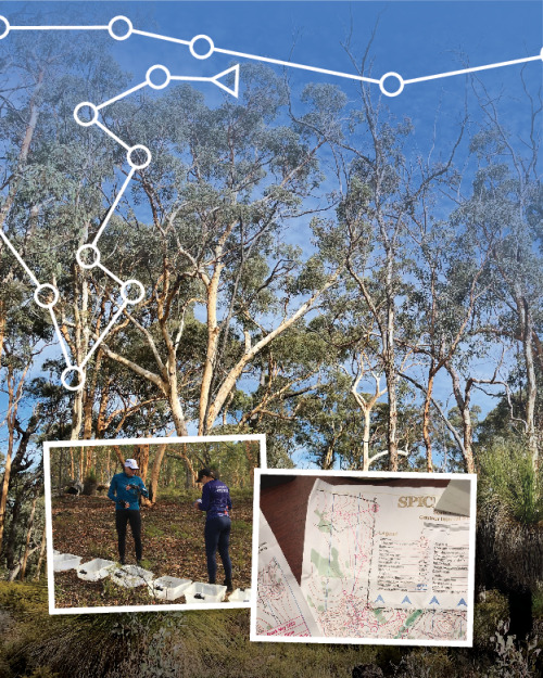
After discussing our options with Carol, one of the friendly volunteer event hosts, Jean-Charles and I settled on the moderate course, which was 3.8 kilometres in length and involved 120 metres of climbing.
Carol helped us register as casual participants for the day and showed us how to clear our e-tags and use them to check in at each control point.
Then, after a quick lesson from Jean- Charles on how to set my compass, we set off to the start point to collect our maps and control description sheets and start our adventure.
Orienteering
We had to navigate through bushland, scrub and dry creeks to find most of our control points, which were a few hundred metres apart.
On our course, being of moderate navigational difficulty, most of our control points aligned with geographical features on the map such as gullies or tracks. This meant if we went off-line, we could usually locate our control point by following the gully or track, once we hit it, in the direction we thought the checkpoint probably was.
As a first-time orienteer, tackling the course as part of a pair meant I had the reassurance of being able to set my direction on my own, but then check with Jean-Charles that we agreed on the direction we should go before heading in search of the next control point.
On at least one occasion I would have walked 180 degrees in the wrong direction had I not had Jean-Charles to cross reference with. He graciously assured me this occasionally happens to everyone.
It was a beautiful morning and we were in no great rush, eventually completing our course in one hour and 40 minutes, having successfully found all 15 control points, and finishing fifth in our category.
Getting hooked
The experienced orienteers mostly seemed to know each other and we were quickly recognised as newcomers, but warmly welcomed.
After finishing our course, I chatted with Hadrien and Ellie, who orienteer most weekends, and with Jan, who’s been orienteering for more than 40 years and is Vice President of Orienteering WA. Their love for the sport was clearly evident and their enthusiasm for it infectious.
Hadrien coordinates Orienteering WA’s mountain bike events, held about once a month over winter, and explained to me how the clubs go about setting courses and how the navigational difficulty is determined by the location of control points in relation to the area’s geographical features.
Jan told me how she came across the sport fortuitously in Canada when she picked up a pamphlet for an orienteering event being held the next day. After heading along, she said she was “hooked straight away”.
“I like being out in the bush and like that it’s a combination of the physical and mental challenge. It requires you to understand how your body and mind respond to physical pressure,” Jan said.
“But what I love most about it is that it’s a sport for life. People of all ages are involved.”
This was certainly evident at the Spice Brook event. I was overtaken at one point by a boy of about 12 (who clearly wasn’t orienteering solo for the first time!), and saw people ranging in age from teenagers through to their 70s and 80s.
Getting lost? Not likely
While most orienteers seemed quite serious, the vibe was convivial and I have no doubt anyone in attendance would have stopped to assist another orienteer needing help.
For all courses at Spice Brook, had you become lost or encountered difficulties, heading due north would have taken you straight to a main track from where you could have easily found the way back to the assembly area.
Do it yourself
Who can orienteer?
Most people—very easy courses are only 2–3 kilometres long and can be navigated without a compass. Some events even have short stringcourses that can be attempted by very young children and toddlers.
When is it?
Check Orienteering WA’s website for upcoming events. Bush and mountain biking events are held over
the winter months and events are held in urban, metropolitan settings over summer.
What do I take?
Water and a compass, if you have one, or you can borrow a compass on the day. If you haven’t preregistered make sure you take cash as many locations don’t have reception to enable card payments. Wear long pants as it’s scratchy, running or hiking shoes, and sun protection. Information about orienteering including how to get started, upcoming events, frequently asked questions and information about ‘Anytime Orienteering’ can be found on Orienteering WA’s website: wa.orienteering.asn.au