Proposed South Coast Marine Park
Have your say on the proposed South Coast Marine Park.
Status:
Draft open for public comment
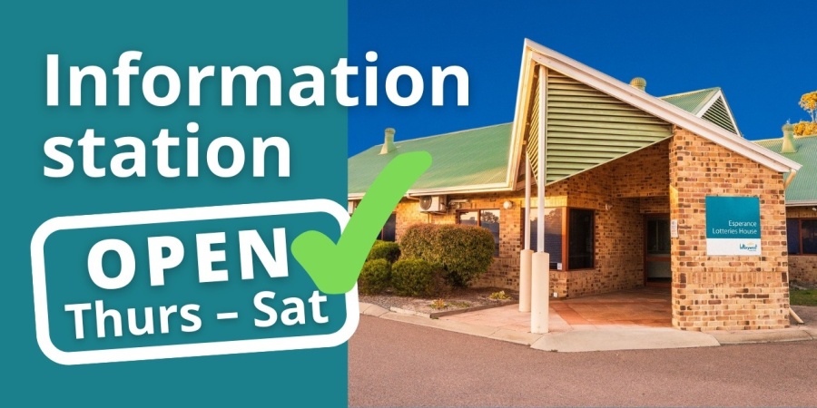
Marine park information station open in Esperance
- Located inside Esperance Lotteries House, 3 Forrest Street.
- Open from 9am-3pm, Thursdays, Fridays, Saturdays.
- Drop in for a chat with our team of marine park planners, marine scientists and community engagement officers.
- Have your questions answered and get guidance on making your submission.
- No bookings required.
- Open for up to eight weeks, from Thursday 18 April onwards.
Indicative management plans released for public comment
You can now have your say on four closely related indicative management plans that collectively form the proposed South Coast Marine Park. There is a separate management plan for each Native Title area to allow for joint management arrangements with the four Traditional Owner groups
Importantly, these four marine areas will be managed as one interconnected ecological system.
Your feedback is important and all feedback will be considered. The marine park will not be created until the final management plans, including final boundaries and zoning schemes, are approved by the Ministers for Environment; Fisheries; and Mines and Petroleum.
The four proposed plans open for public comment
Each highlighted area in the static map below has a corresponding management plan.
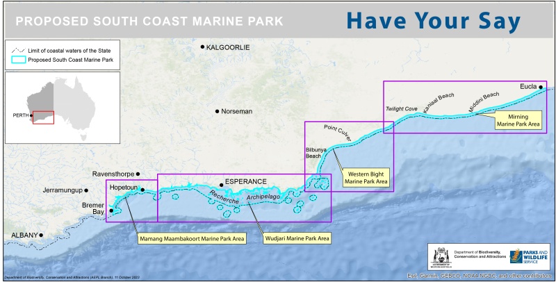

Mamang Maambakoort Marine Park joint management plan
Wudjari Marine Park joint management plan

Western Bight Marine Park management plan
Mirning Marine Park Joint management plan
Interactive map
Interactive map legend for Proposed South Coast Marine Park
How do I make a submission on the indicative management plans and zoning schemes for the proposed South Coast Marine Park?
Submissions on the indicative management plans and their zoning schemes can be made during the four-month public comment period to 16 June 2024. Submissions are encouraged via the online survey at the link below but can also be made via email or post.
To ensure your submission is as effective as possible:
- be clear and concise
- refer your points to the page numbers, specific proposed zones or specific sections in the plan
- say whether you agree or disagree with any or all of the management objectives and strategies – clearly state your reasons, particularly if you disagree
- give sources of information where possible
- suggest alternatives for those aspects of the plan with which you disagree
- be respectful – submissions with abusive or racist comments will not be considered.
Online survey:
dbca.wa.gov.au/pscmp
Email:
pscmp@dbca.wa.gov.au
Post:
Planning Unit
Aboriginal Engagement, Planning and Lands Branch
Department of Biodiversity, Conservation and Attractions
Locked Bag 104
BENTLEY DELIVERY CENTRE WA 6893
Where can I dive, surf and boat in the proposed marine park?
Where can I recreationally fish in the proposed marine park?
FAQs
How can I make my comments count?
All public submissions will be reviewed and assessed. The management plan may be amended if a submission:
- provides additional information of direct relevance to management
- indicates a change in (or clarifies) government legislation or management policy
- proposes strategies that would better achieve management objectives
- indicates omissions, inaccuracies or a lack of clarity.
The management plan may not be amended if a submission:
- clearly supports proposals in the plan
- makes general or neutral statements or no change is sought
- refers to issues beyond the scope of the plan
- refers to issues that are already noted within the plan or already taken into consideration during its preparation
- is one among several widely divergent viewpoints received on the topic but the approach in the plan is still considered the best option
- contributes options that are not feasible (generally due to conflict with legislation or government policy)
- is based on unclear or factually incorrect information.
A summary of public submissions will be made available along with the final management plan.
Will submissions from locals count more than submissions from people who don’t live near or use the South Coast?
All submissions will be considered on their merits and none will be given greater weighting than others. See the question above ‘How can I make my comments count?’ to help you make an effective submission. Fine-scale information from the community on how the park is used is more helpful than very general comments. Consideration will be given to adjusting zone boundaries to better accommodate uses such as fishing, based on any fine scale information you provide.
What is a marine park?
Marine parks are one of the three marine reserve categories that can be created under the Conservation and Land Management Act 1984. They are created to help conserve marine habitats, biodiversity and cultural heritage values, while allowing for a range of sustainable uses including fishing, diving, boating and tourism.
Why do we need marine parks along the south coast?
Marine parks conserve the marine environment for people to continue to use and enjoy into the future. WA’s oceans are among the healthiest in the world, but pressures on them are growing. Marine parks help protect areas that are still in the most natural condition. By conserving and maintaining healthy marine ecosystems we can help to increase their resilience against threats such as climate change, pollution and overuse of resources.
There is currently only one marine park in State waters on the south coast, the 1442 hectare Walpole and Nornalup Inlets Marine Park. It protects the only permanently open estuary on the south coast but doesn’t extend into coastal waters.
The creation of the South Coast Marine Park will significantly contribute to WA’s network of marine reserves and Australia’s National Representative System of Marine Protected Areas. They will protect representative marine habitats, the region’s remarkable biodiversity and important cultural heritage sites, while allowing for sustainable use.
Where is the proposed South Coast Marine Park?
The proposed outer boundary of the marine park extends from Point Hood, near Bremer Bay, eastward to the WA-SA border. It extends offshore to the limit of coastal waters of the State. Coastal waters of the State extend three nautical miles seaward of the Territorial Sea Baseline, including around offshore islands. Port areas will be excluded from the final marine park boundary. This area has immense conservation, scientific and public recreation values, as well as value for commercial and recreational fishing activities.
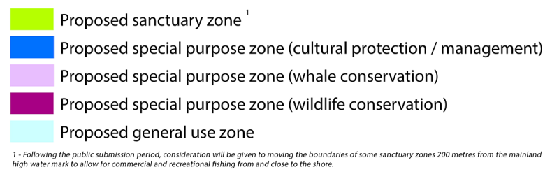
What are the different types of zones within a marine park?
Different zones in WA marine parks provide for different uses:
- General use zone - used to conserve the marine environment while allowing sustainable commercial and recreational activities to continue.
- Recreation zone - used primarily for recreational purposes, including recreational fishing where it is compatible with the primary recreation purpose of the zone. Commercial fishing is prohibited in recreation zones.
- Special purpose zone - zones with a specific conservation purpose, such as protecting marine habitats or cultural heritage values. Commercial and recreational activities that are compatible with the specific conservation purpose of the zone are allowed.
- Sanctuary zones - provide the highest level of protection for marine plants and animals. These ‘look but don’t take’ areas are the only zones that prohibit all types of fishing and collecting, and mineral and petroleum extraction. People can continue to enjoy nature-based activities such as wildlife watching, diving, snorkelling and boating, in sanctuary zones.
How were the proposed zones developed?
After determining the proposed marine park outer boundary, the area was assessed to identify all the different habitat types to ensure that all the natural values within the marine park were adequately protected; and an analysis of use of the area was undertaken.
- Proposed sanctuary (no take) zones comprising 25 per cent of the park were designed to include representative (typical) areas of different habitat types and biodiversity, threatened species habitat, nursery or breeding areas, important cultural sites, and internationally and nationally recognised areas.
- Seventy-five per cent of the proposed park will remain open to commercial and recreational fishing.
- Social and economic factors have influenced the placement of zones to minimise impacts on existing use.
- Tourism operations are an important aspect of the marine park, often enabling visitors to better appreciate and understand the area and its natural values. Commercial tour operators require a licence which allows them to operate in different zones of a marine park depending on their type of activity.
- Thirteen per cent of the park has been zoned special purpose (cultural protection / cultural management) and six percent as special purpose zone (whale conservation) with no restriction to recreational or commercial fishing.
- One per cent of the park has been zoned special purpose zone (wildlife conservation) which restricts commercial and recreational fishing other than hand collection of abalone, crustacean, octopus, aquarium fish and specimen shells.
- Sanctuary zones are important for research and monitoring so we can continue to learn about the marine park’s ecological, cultural and social values, detect impacts and manage change.
How can I still use the marine park?
The proposed marine park is highly valued by the local community and visitors. The majority of activities which are undertaken in the proposed marine park – including swimming, diving, nature appreciation and four-wheel drive beach access will not change.
Where can I dive, surf and boat in the proposed marine park?
A detailed map of the recreational zones is available in the downloads section on each of the proposed parks pages.
Will recreational fishing be allowed in the proposed marine park?
Yes, you will be able to continue to enjoy fishing in the proposed South Coast Marine Park. To conserve representative habitats and biodiversity, recreational fishing will not be allowed in sanctuary zones. The proposed park has been carefully designed to minimise impacts to recreational fishers while helping to ensure a healthy marine environment that will support sustainable fishing into the future.
Following the public submission period, consideration will be given to moving the boundaries of some sanctuary zones 200 metres from the mainland high-water mark to allow for recreational fishing from and close to the shore.
Where can I recreationally fish in the proposed marine park?
A detailed map of the recreational fishing zones is available in the downloads section on each of the proposed parks page.
Will commercial fishing be allowed in the proposed marine park?
Yes, commercial fishing is important to the region’s economy. Commercial activities will be allowed within the majority of the proposed South Coast Marine Park. To conserve representative habitats and biodiversity, commercial fishing will not be allowed in sanctuary zones.
The proposed marine park has been carefully designed to minimise impacts to commercial fishers and incorporate any existing restrictions into management arrangements where possible. For example, current restrictions to commercial fishing activities on the south coast, such as the Australian sea lion Gillnet Exclusion Zones, have been considered in the development of the marine park zoning plan.
Commercial fishers are encouraged to make a submission on the indicative management plans.
Following the public submission period, consideration will be given to moving the boundaries of some sanctuary zones 200 metres from the mainland high-water mark to allow for recreational fishing from and close to the shore.
Will I be compensated for any impacts that occur to my business as a result of the creation of the proposed South Coast Marine Park?
Commercial fishers who hold an authorisation and suffer a loss arising from the creation of a marine park in WA may be eligible for compensation under the Fishing and Related Industries Compensation (Marine Reserves) Act 1997.
Department of Primary Industries and Regional Development (DPIRD) is responsible for administering the Fishing and Related Industries Compensation (Marine Reserves) Act but is also exploring alternative adjustment or compensation measures for commercial fishers who may be impacted by the establishment of the marine park.
Will I still be able to drive and camp along the beach?
Yes. You will still be able to drive, camp or have a campfire on the beach anywhere these activities are currently allowed. Rules for terrestrial areas alongside marine parks are mostly determined by local authorities and not DBCA (except for national parks) so the marine park won’t affect these kinds of activities. The marine park boundaries begin at the high-water mark.
Will I still be able to fish from the beach?
Yes, shore fishing from the beach will continue to be permitted in the majority of the proposed marine park. Sanctuary zones, which provide the highest level of protection for marine plants and animals, are proposed for approximately 25 per cent of the proposed marine park but will impact only about 22 per cent of the mainland coast (excluding estuaries and islands).
Following the public submission period, consideration will be given to moving the boundaries of some sanctuary zones 200 metres from the mainland high-water mark to allow for commercial and recreational fishing from and close to the shore.
Can I travel through or anchor in a sanctuary zone if I have fishing rods or fish on board?
Yes, anchoring is permitted in sanctuary zones. You may have fish and fishing rods on board, but fishing gear must be stowed. You may not fish in sanctuary zones.
Can beach access and/or waters be closed temporarily or seasonally (e.g. due to poor weather, whale migrations, seasonal values etc)?
No, not in relation to the marine park. Beach access arrangements are matters for the relevant land manager and are a separate issue. As has always been the case, beach access can be temporarily closed for safety or other reasons. While temporary or seasonal closures can be used over the marine environment to protect wildlife values, the need for such closures has not been identified in the planning process.
Will I be able to take my dog into the marine park?
You will be able to continue to bring dogs to any beaches where they are currently permitted by the relevant land managers. In marine park waters please ensure dogs stay on boats so they do not interact with marine life. As has always been the case, dogs can’t go ashore onto island nature reserves.
Can I use a drone in a marine park?
Personal drones are permitted in marine parks, subject to CASA regulations. Fishing with drones is permitted in general use and special purpose zones. Commercial drones require a license from DBCA.
Will there be additional restrictions on spearfishing?
Spearfishing will be permitted anywhere line fishing is allowed (75 per cent of the marine park). Sanctuary zones are no take areas where no fishing of any kind is permitted.
When will fishing restrictions take effect in the marine park?
Once the final management plans are released, the marine park zoning scheme is gazetted under the CALM Act. Notices are then gazetted under the Fish Resources Management Act 1984 to give effect to fishing prohibitions in the marine park. There will be a transition period between gazettal of the zoning scheme and implementation of fishing prohibitions under the FRMA, with the focus during this time on education and awareness.
Will I need to register or pay to visit the marine park?
No.
Are artificial reefs, fish aggregating devices and moorings allowed in the marine park?
Moorings are permitted in marine parks in designated areas. Artificial reefs and fish aggregating devices are not permitted in marine parks.
How have stakeholders been involved throughout the process?
Community and stakeholder consultation has been ongoing since 2019 and has been integral to informing the planning and development of the draft plans. The primary engagement mechanism from late 2021 to early 2023 has been the Community Reference Committee (CRC), informed by Sector Advisory Groups that have provided local advice on the development of the indicative management plans, including the indicative boundary and zoning schemes. The CRC was formed to ensure views from the local community could be heard and was not a decision-making body.
Why are there four indicative management plans?
The proposed marine park is being developed in partnership with Traditional Owners, which is why the State Government has released four indicative management plans to align with four Native Title determination areas.
Importantly, these four marine parks will be managed as one interconnected ecological system.
Is customary fishing permitted in the marine park?
Yes, customary fishing is permitted in all zones of the marine park. The ability for Aboriginal people to carry out cultural activities, including fishing and hunting is an important part of Aboriginal culture and connection to the land and sea.
Customary fishing applies to an Aboriginal person who has a traditional connection with the area being fished and is fishing for personal, domestic, ceremonial, educational or non‐commercial needs.
How are tourism interests accommodated in the marine park?
The marine park will be managed with the aim of encouraging visitors and locals alike. There will be a focus on tourism that respects the area’s cultural, ecological and wilderness values while enjoying a range of recreational activities.
Will charter boats require additional approvals to operate in the marine park?
Yes. Anyone operating a tourism or recreation business in lands and waters managed by DBCA requires a commercial operations licence. DBCA provides operators with up-to-date information, news and marketing opportunities. By complying with licence requirements, operators also help to safeguard the beauty and diversity of WA’s natural environments and attractions.
How can I stay up to date?
You can stay up to date with the latest information by visiting the website at dbca.wa.gov.au/pscmp
When will the proposed marine park be created?
The proposed South Coast Marine Park is planned to be created in the second half of 2024. There will be a grace period before restrictions to commercial and recreational fishing come into effect.
Who is responsible for marine parks?
Marine parks are vested in the Conservation and Parks Commission. Some areas may be jointly vested with Traditional Owners through the relevant body corporate. It is intended that the proposed South Coast Marine Park will be jointly managed by the area’s Traditional Owners and DBCA. DBCA also works closely with other State Government agencies, such as DPIRD, which manages fishing in WA marine reserves.
Community engagement
Local community input and knowledge is crucial to planning for the proposed marine parks.
Consultation to date
DBCA with the Traditional Owners of the four proposed marine parks and DPIRD, has undertaken a rigorous process of engaging with key stakeholders, including commercial and recreational fishers, community members and marine scientists. This has involved:
- The establishment of a Community Reference Committee (CRC) that met six times over the 18 months up to March 2023. Following a request from members, the final CRC meeting was deferred for an additional month to allow stakeholders, including fishers, more time to consider unresolved matters.
- 10 different Sector Advisory Groups (SAGs) comprising representatives of key stakeholder groups involved in activities within the proposed marine park.
- Separate to the CRC process, DBCA also conducted 31 individual meetings in Albany, Hopetoun, Esperance, and Perth with commercial fishers and seven with recreational fishers. Importantly, every commercial fishing business with a license in the south coast was contacted and each given the opportunity to meet 1:1 with DBCA.
- DBCA and DPIRD representatives have met with a range of stakeholders including the Shire of Esperance and fishing peak bodies.
Reports
Find out more about the proposed park’s values and scientific knowledge of the area: